Water is life—especially in Texas. Native Americans, explorers, settlers, and tourists have been attracted to Texas’ springs for thousands of years. Springs give rise to beautiful rivers, they reflect the health of our most important aquifers, and they are the center of our communities, providing a vital connection to nature and strengthening local economies.
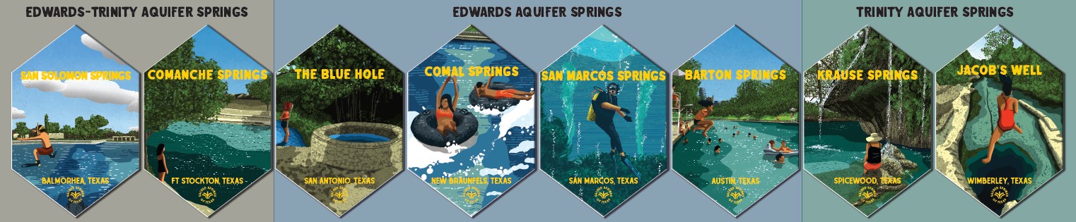
There are thousands of springs throughout Texas issuing from numerous aquifers in the state, each with its own characteristics and challenges. The Sacred Springs Kite Exhibition highlights eight of Texas’ most unique springs. These are true treasures for the state that deepen the human connection to the environment and inspire stewardship for thousands who come to visit these remarkable springs each year. This poster series serves as an extension of the kite exhibition to give more information on each of the eight featured springs and the challenges, protections, and access for each one. The more we learn about springs and their connection to our health and wellbeing, the better we can protect Texas’ springs, their rivers, and our water supplies together.

Art4Water, a program of the Watershed Association, is an initiative that advocates for environmental protection through the lens of art. The Watershed Association is a 501c(3) non-profit based in Wimberley, Texas focused on water protection through land conservation, science, and regenerative education programs. In order to carry out our mission, we rely upon generous donations from people like you who care about protecting and preserving Texas’ natural beauty. Your contributions are tax-deductible.

Click the spring name below to learn more:
Springs Terminology (in alphabetical order)
The following basic definitions will help better understand the terms used in the Sacred Springs posters.
Aquifer – A body of rock that can store and transmit water. Oftentimes, several rock layers make up one aquifer because groundwater can move from one layer to another.
Artesian—This usually refers to a spring, well, or zone where natural pressure within an aquifer forces a constant supply of water to the surface.
Contributing Zone – An area where rainfall and runoff drains to creeks and rivers and then flows to a downstream area where it soaks into the groundwater system as recharge.
Cubic foot per second (cfs) – A flow rate measurement used in describing surface water or spring flow. One cubic foot per second equals about 374 gallons per minute.
Groundwater conservation district – A local governmental agency with an elected Board of Directors tasked with managing groundwater for all users. Typically, groundwater conservation districts are created by the Texas Legislature through enabling legislation based on local groundwater management needs and goals.
Karst – The term ‘Karst’ refers to either features or terrain formed by dissolution. Think holes in the rock. Water erodes soluble rocks such as limestone, dolomite, and gypsum creating features like caves, sinkholes, and springs. Karst landscapes are characterized by underground drainage systems where surface water and groundwater systems are linked.
Impervious cover – A surface covered with any material that impedes or prevents the natural infiltration of water into the ground. Parking lots, roofs, buildings, and streets are examples of impervious cover.
Recharge Zone – An area where water enters an aquifer. Typically, a rock layer associated with the aquifer is exposed at the land surface allowing water from the surface to recharge or replenish water supplies in that aquifer.
Spring – A location where groundwater naturally emerges at the surface either by gravity or through artesian pressure.
Springshed – The section of an aquifer that drains to a spring.
Watershed – The area of land that drains to a stream or river.
Edwards-Trinity Plateau Aquifer
Comanche Springs
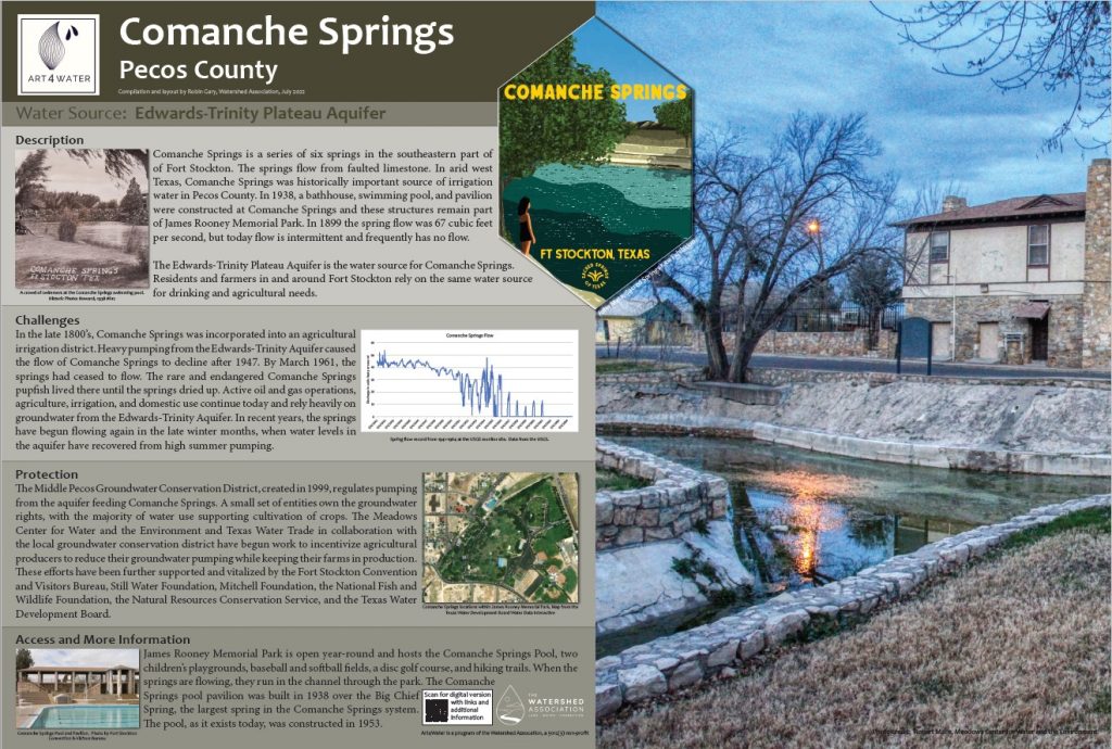
| Source: Edwards-Trinity Plateau Aquifer |
|
Description Comanche Springs is a series of springs in the southeastern part of the town of Fort Stockton. The springs, the source of Comanche Creek, flows from faulted limestone. In arid west Texas, Comanche Springs was a historically important source of irrigation water in Pecos County. By 1938, a bathhouse, swimming pool, and pavilion were constructed at Comanche Springs and these structures remain part of James Rooney Memorial Park. In 1899 the spring flow was 67 cubic feet per second, but today flow is intermittent and frequently has no flow. The Edwards-Trinity Plateau Aquifer is the water source for Comanche Springs. Residents and farmers in and around Fort Stockton rely on the same water source for drinking and agricultural needs. |
|
Challenges In the late 1800s, Comanche Springs was incorporated into an agricultural irrigation district. Heavy pumping from the Edwards-Trinity Aquifer caused the flow of Comanche Springs to decline after 1947. By March 1961, the springs had completely ceased to flow. The rare and endangered Comanche Springs pupfish lived there until the springs dried up. Active oil and gas operations, agriculture, irrigation, and domestic use continue today and rely heavily on groundwater from the Edwards-Trinity Aquifer. In recent years, the springs have begun flowing again in the late winter months, when water levels in the aquifer have recovered from high summer pumping. |
|
Protection The Middle Pecos Groundwater Conservation District, created in 1999, regulates pumping from the aquifer feeding Comanche Springs. A small set of entities own the groundwater rights, with the majority of water use supporting the cultivation of crops. Texas Water Trade has begun work to incentivize agricultural producers to reduce their groundwater pumping while keeping their farms in production. These efforts have been supported and vitalized by the Meadows Center for Water and the Environment, Fort Stockton Convention and Visitors Bureau, Still Water Foundation, Mitchell Foundation, the National Fish and Wildlife Foundation, the Natural Resources Conservation Service, and the Texas Water Development Board. |
|
Access James Rooney Memorial Park is open year-round and hosts the Comanche Springs Pool, two children’s playgrounds, baseball, and softball fields, a disc golf course, and hiking trails. When the springs are flowing, they run in the channel through the park and there is a trail that follows the channel through the park. The Comanche Springs pool pavilion was built in 1938 over the Big Chief Spring, the largest spring in the Comanche Springs system. The pool, as it exists today, was constructed in 1953. The annual Fort Stockton Water Carnival is held at the historic Comanche Springs Pool on the third weekend of July. |
| Organizations:
More info: |
San Solomon Springs
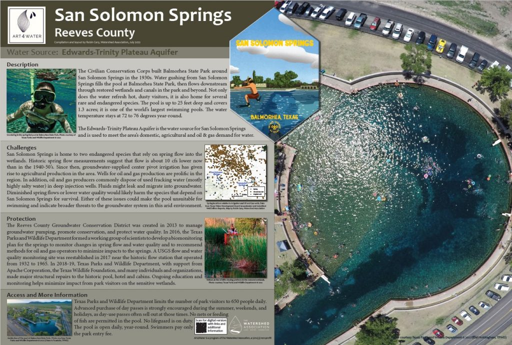
| Source: Edwards-Trinity Plateau Aquifer |
|
Description The Civilian Conservation Corps built Balmorhea State Park around San Solomon Springs in the 1930s. Water gushing from San Solomon Springs fills the pool at Balmorhea State Park, then flows downstream through restored wetlands and canals in the park and beyond. Not only does the water refresh hot, dusty visitors, but it is also home to several rare and endangered species. The pool is up to 25 feet deep and covers 1.3 acres; it is one of the world’s largest swimming pools. The water temperature stays at 72 to 76 degrees year-round. The Edwards-Trinity Plateau Aquifer is the water source for San Solomon Springs and is used to meet the area’s domestic, agricultural, and oil & gas demand for water. |
|
Challenges San Solomon Springs is home to two endangered species that rely on spring flow into the wetlands. Historic spring flow measurements suggest that flow is about 10 cfs lower now than in the 1940-50s. Since then, groundwater-supplied center pivot irrigation has given rise to agricultural production in the area. Wells for oil and gas production is prolific in the region. In addition, oil and gas producers commonly dispose of used fracking water (mostly highly salty water) in deep injection wells. Fluids might leak and migrate into groundwater. Diminished spring flows or lower water quality would likely harm the species that depend on San Solomon Springs for survival. Either of these issues could make the pool unsuitable for swimming and indicate broader threats to the fragile groundwater system in this arid environment. |
|
Protection The Reeves County Groundwater Conservation District was created in 2013 to manage groundwater pumping, promote conservation, and protect water quality. In 2016, the Texas Parks and Wildlife Department formed a working group of scientists to develop a biomonitoring plan for the springs to monitor changes in spring flow and water quality and to recommend best management practices for oil and gas operators to minimize impacts to the springs. A USGS flow and water quality monitoring site was reestablished in 2017 near the historic flow station that operated from 1932 to 1965. In 2018-2019, Texas Parks and Wildlife Department, with support from Apache Corporation, the Texas Wildlife Foundation, and many individuals and organizations, made major structural repairs to the historic pool, hotel, and cabins. Ongoing education and monitoring helps minimize the impact of park visitors on sensitive wetlands. |
|
Access Texas Parks and Wildlife Department limits the number of park visitors to 650 people daily. Advanced purchase of day passes is strongly encouraged during the summer, weekends, and holidays, as day-use passes often sell out at those times. No nets or feeding of fish are permitted in the pool. No lifeguard is on duty. The pool is open daily, year-round. Swimmers pay only the park entry fee. |
| Organizations:
More info: |
Edwards Aquifer
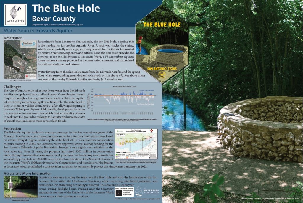
The Blue Hole
|
Source: Edwards Aquifer |
|
Description Just minutes from downtown San Antonio, sits the Blue Hole, a spring that is the headwaters for the San Antonio River. A rock wall circles the spring, which was reported once as a geyser rising several feet in the air frequented by Native Americans, explorers, and settlers. Now, the Blue Hole provides the centerpiece for the Headwaters at Incarnate Word, a 53-acre urban riparian forest nature sanctuary protected by a conservation easement and maintained by staff and dedicated volunteers. Water flowing from the Blue Hole comes from the Edwards Aquifer, and the spring flows when surrounding groundwater levels reach or rise above 672 feet above mean sea level at the nearby Edwards Aquifer Authority J-17 monitor well. |
|
Challenges The City of San Antonio relies heavily on water from the Edwards Aquifer to supply residents and businesses. Groundwater use and frequent droughts lower groundwater levels within the aquifer, which directly impacts spring flow at Blue Hole. The water level in the J-17 monitor well has been above 672 feet allowing the spring to flow only 24% of the past 10 years. Additionally, development increases the amount of impervious cover which limits the ability of water to soak into the ground to recharge the aquifer and increases rates of runoff that can lead to more severe flash floods. |
|
Protection The Edwards Aquifer Authority manages pumpage in the San Antonio segment of the Edwards Aquifer and coordinates pumpage reductions for permitted water users based on several drought triggers, including the water level at J-17. As a proactive conservation measure starting in 2000, San Antonio voters approved several rounds of funding for the San Antonio Edwards Aquifer Protection through a one-eighth cent addition to the local sales tax. Over 21 years, the program has raised $300 million in conservation lands; through conservation easements, land purchases, and matching investments has successfully protected over 240,000 acres to date. In celebration of the Sisters of Charity of the Incarnate Word’s 150th anniversary, the Congregation and its ministry, Headwaters at Incarnate Word, established a conservation easement to permanently protect the Headwaters Sanctuary in 2022. |
|
Access Guests are welcome to enjoy the trails, see the Blue Hole and visit the headwaters of the San Antonio River within the Headwaters Sanctuary while respecting established guidelines and restrictions. No swimming or wading is allowed. The Sanctuary is open year-round during daylight hours. Parking near the Sanctuary entrance is courtesy of the University of the Incarnate Word; please respect their parking restrictions. |
| Organizations:
More info:
|
Comal Springs
|
Source: Edwards Aquifer |
|
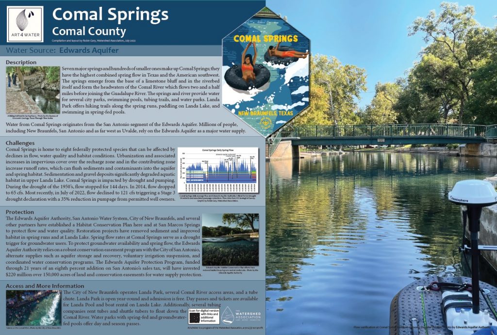
Description Seven major springs and hundreds of smaller ones make up Comal Springs; they have the highest combined spring flow in Texas and the American Southwest. The springs emerge from the base of a limestone bluff and in the riverbed itself and form the headwaters of the Comal River which flows two and a half miles before joining the Guadalupe River. The springs and river provide water for several city parks, swimming pools, tubing trails, and water parks. Landa Park offers hiking trails along the spring runs, paddling on Landa Lake, and swimming in spring-fed pools. Water from Comal Springs originates from the San Antonio segment of the Edwards Aquifer. Millions of people, including New Braunfels, San Antonio, and as far west as Uvalde, rely on the Edwards Aquifer as a major water supply. |
|
Challenges Comal Springs is home to eight federally protected species that can be affected by declines in flow, water quality, and habitat conditions. Urbanization and associated increases in impervious cover over the recharge zone and in the contributing zone increase runoff rates, which can flush sediments and contaminants into the aquifer and spring habitat. Sedimentation and gravel deposits significantly degraded the aquatic habitat in upper Landa Lake. Comal Springs is impacted by drought and pumping. During the drought of the 1950s, the flow stopped for 144 days. In 2014, flow dropped to 65 cfs. Most recently, in July of 2022, flow declined to 121 cfs triggering a Stage 3 drought declaration with at least a 35% reduction in pumpage from permitted well owners. |
|
Protection The Edwards Aquifer Authority, San Antonio Water System, City of New Braunfels, and several other partners have established a Habitat Conservation Plan here and at San Marcos Springs to protect flow and water quality. Restoration projects have removed sediment and improved habitat in spring runs and at Landa Lake. Spring flow rates at Comal Springs serve as a drought trigger for groundwater users. To protect groundwater availability and spring flow, the Edwards Aquifer Authority relies on a robust conservation easement program with the City of San Antonio, alternate supplies such as aquifer storage and recovery, voluntary irrigation suspension, and coordinated water conservation programs. The Edwards Aquifer Protection Program, funded through 21 years of an eight percent addition on San Antonio’s sales tax, will have invested $220 million over 150,000 acres of land and conservation easements for water supply protection. |
|
Access The City of New Braunfels operates Landa Park, several Comal River access areas, and a tube chute. Landa Park is open year-round and admission is free. Day passes and tickets are available for Landa Pool and boat rental on Landa Lake. Additionally, several tubing companies rent tubes and shuttle tubers to float down the Comal River. Water parks with spring-fed and groundwater-fed pools offer day and season passes. |
| Organizations:
More info:
|
San Marcos Springs
|
Source: Edwards Aquifer |
|
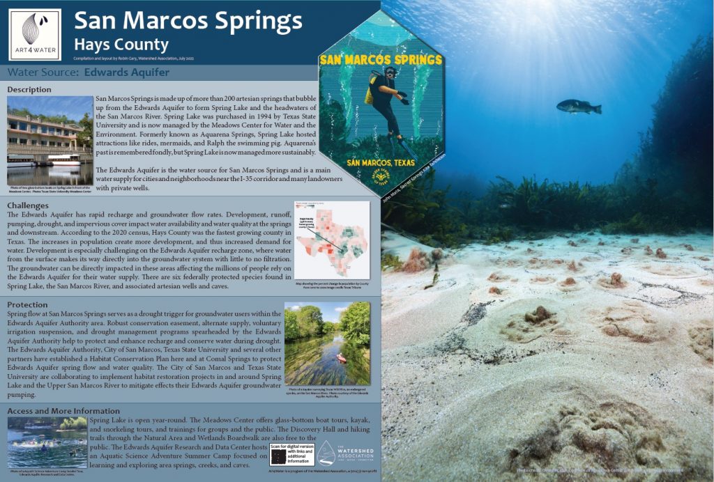
Description San Marcos Springs is made up of more than 200 artesian springs that bubble up from the Edwards Aquifer to form Spring Lake and the headwaters of the San Marcos River. Spring Lake was purchased in 1994 by Texas State University and is now managed by the Meadows Center for Water and the Environment. Formerly known as Aquarena Springs, Spring Lake hosted attractions like rides, mermaids, and Ralph the swimming pig. Aquarena’s past is remembered fondly, but Spring Lake is now managed more sustainably. The Edwards Aquifer is the water source for San Marcos Springs and is a main water supply for cities and neighborhoods near the I-35 corridor and many landowners with private wells. |
|
Challenges The Edwards Aquifer has rapid recharge and groundwater flow rates. Development, runoff, pumping, drought, and impervious cover impact water availability and water quality at the springs and downstream. According to the 2020 census, Hays County was the fastest-growing county in Texas. The increases in population create more development, and thus increased demand for water. Development is especially challenging in the Edwards Aquifer recharge zone, where water from the surface makes its way directly into the groundwater system with little to no filtration. The groundwater can be directly impacted in these areas affecting the millions of people who rely on the Edwards Aquifer for their water supply. There are six federally protected species found in Spring Lake, the San Marcos River, and associated artesian wells and caves. |
|
Protection Spring flow at San Marcos Springs serves as a drought trigger for groundwater users within the Edwards Aquifer Authority area. A robust conservation easement, alternate supply, voluntary irrigation suspension, and drought management programs spearheaded by the Edwards Aquifer Authority help to protect and enhance recharge and conserve water during a drought. The Edwards Aquifer Authority, City of San Marcos, Texas State University, and several other partners have established a Habitat Conservation Plan here and at Comal Springs to protect Edwards Aquifer spring flow and water quality. The City of San Marcos and Texas State University are collaborating to implement habitat restoration projects in and around Spring Lake and the Upper San Marcos River to mitigate their Edwards Aquifer groundwater pumping. |
|
Access Spring Lake is open year-round. The Meadows Center offers glass-bottom boat tours, kayak, and snorkeling tours, and training for groups and the public. The Discovery Hall and hiking trails through the Natural Area and Wetlands Boardwalk are also free to the public. The Edwards Aquifer Research and Data Center hosts an Aquatic Science Adventure Summer Camp focused on learning and exploring area springs, creeks, and caves. |
| Organizations:
More info: |
Barton Springs
|
Source: Edwards Aquifer |
|
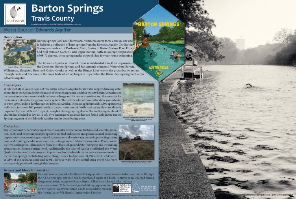
Description Barton Springs Pool near downtown Austin measures three acres in size and is fed from a collection of karst springs from the Edwards Aquifer. Barton Springs is made up of Parthenia (Main) Spring in Barton Springs Pool, Eliza, Old Mill (Sunken Garden), and Upper Barton. With an average temperature of 68-70 degrees, these springs make the pool ideal for year-round swimming. The Edwards Aquifer of Central Texas is subdivided into three segments—the Northern, Barton Springs, and San Antonio segments. Water from Barton, Williamson, Slaughter, Bear, and Onion Creeks as well as the Blanco River enters the groundwater system through faults and fractures in the creek beds which recharges or replenishes the Barton Springs Segment of the Edwards Aquifer. |
|
Challenges While the City of Austin does not rely on the Edwards Aquifer for its water supply (drinking water comes from the Colorado River), much of the recharge zone is within the city limits. Urbanization increases impervious cover which reduces recharge and increases stormflow and the potential for contaminants to enter the groundwater system. The well-developed flow paths allow groundwater to travel up to 7 miles a day through the Edwards Aquifer. There are approximately 1,300 operational wells with just over 100 permit holders (larger water users). Wells and spring flow are directly impacted by Central Texas’ frequent droughts. The average spring flow at Barton Springs is about 65 cfs but has reached as low as 13 cfs. Two endangered salamanders are found only in the Barton Springs segment of the Edwards Aquifer and its contributing zone. |
|
Protection The City of Austin, Barton Springs Edwards Aquifer Conservation District, and several regional non-profit and environmental groups have created ordinances and policies aimed at limiting impervious cover, requiring advanced stormwater and wastewater controls, protecting spring flow, and limiting development over the recharge zone. Habitat Conservation Plans protect the two endangered salamanders from the effects of groundwater pumping and swimming operations in Barton Springs pool. Additionally, the City of Austin established the Water Quality Protection Lands program to purchase land and establish conservation easements in the Barton Springs contributing and recharge zones; to date, over 34,194 acres (17,640 acres or 28% of the recharge zone and 15,911 acres or 9.4% of the contributing zone) have been permanently protected through this program. |
|
Access To avoid lines, purchase day and season passes for Barton Springs pool online through the ATXswims app. Passes can be purchased onsite at a kiosk. Entry fees are charged for regular guarded swim hours; no fees are charged for the final hour, 9-10 pm. Zilker Park hike and bike trails are open year-round. Volunteer and guided hiking opportunities on the Water Quality Protection Lands are available through the Austin Water, Wildlands Conservation Division. |
Organizations:
More info: |
Trinity Aquifer
Jacob’s Well
| Source: Middle Trinity Aquifer |
|
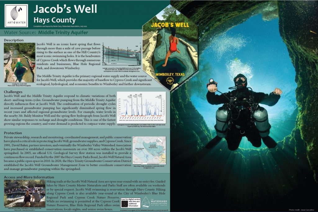
Description Jacob’s Well is an iconic karst spring that flows through more than a mile of cave passage before rising to the surface as one of the Hill Country’s most iconic swimming holes. It is the headwaters of Cypress Creek which flows through numerous residents and businesses, Blue Hole Regional Park, and downtown Wimberley. The Middle Trinity Aquifer is the primary regional water supply and the water source for Jacob’s Well, which provides the majority of baseflow to Cypress Creek and significant ecological, hydrological, and economic benefits to Wimberley and farther downstream. |
|
Challenges Jacob’s Well and the Middle Trinity Aquifer respond to climatic variations of both short- and long-term cycles. Groundwater pumping from the Middle Trinity Aquifer directly influences flow at Jacob’s Well. The combination of periodic drought cycles and increased groundwater pumping has significantly diminished spring flow in recent years and affected regional groundwater levels. For example, water levels in the nearby Mt. Baldy Monitor Well and the spring flow hydrograph from Jacob’s Well show similar responses to recharge and drought conditions. This is one of the fastest-growing regions in the country, and water demand is predicted to outpace water supply. |
|
Protection Private stewardship, research and monitoring, coordinated management, and public conservation have played a critical role in protecting Jacob’s Well, groundwater supplies, and Cypress Creek. Since 1991, David Baker, partner investors, and eventually the Wimberley Valley Watershed Association have purchased or established conservation easements on over 300 acres within the Jacob’s Well Springshed. In 2005, an official U.S. Geological Survey flow station was installed to provide a continuous flow record. Funded by the 2007 Hays County Parks Bond, Jacob’s Well Natural Area became a public open space in 2010. In 2020, the Hays Trinity Groundwater Conservation District established Jacob’s Well Groundwater Management Zone to better coordinate conservation and manage groundwater pumping within the springshed. |
|
Access Hiking trails at the Jacob’s Well Natural Area are open year-round with no entry fee. Guided hikes by Hays County Master Naturalists and Parks Staff are often available on weekends or by special request. Jacob’s Well swimming is by reservation through Hays County. Hiking along Cypress Creek is also available year-round at the City of Wimberley’s Blue Hole Regional Park and Cypress Creek Nature Preserve. While no swimming is permitted at the Cypress Creek Nature Preserve, Blue Hole Regional Park offers swim reservations, locals nights, and senior swim hours. |
Organizations:
More info: |
Krause Springs
|
Source: Lower Trinity Aquifer |
|
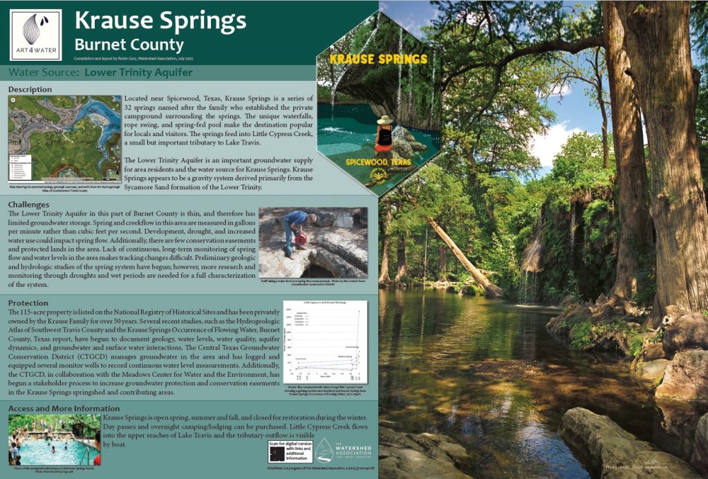
Description: Located near Spicewood, Texas, Krause Springs is a series of 32 springs named after the family who established the private campground surrounding the springs. The unique waterfalls, rope swing, and spring-fed pool make the destination popular among locals and visitors. The springs feed into Little Cypress Creek, a small but important tributary to Lake Travis. The Lower Trinity Aquifer is an important groundwater supply for area residents and the water source for Krause Springs. Krause Springs appears to be a gravity system derived primarily from the Sycamore Sand formation of the Lower Trinity. |
|
Challenges The Lower Trinity Aquifer in this part of Burnet County is thin and therefore has limited groundwater storage. Spring and creek flow in this area are measured in gallons per minute rather than cubic feet per second. Development, drought, and increased water use could impact spring flow. Additionally, there are few conservation easements and protected lands in the area. The lack of continuous, long-term monitoring of spring flow and water levels in the area makes tracking changes difficult. Preliminary geologic and hydrologic studies of the spring system have begun; however, more research and monitoring through droughts and wet periods are needed for a full characterization of the system. |
|
Protection The 115-acre property is listed on the National Registry of Historical Sites and has been privately owned by the Krause Family for over 50 years. Several recent studies, such as the Hydrogeologic Atlas of Southwest Travis County and the Krause Springs Occurrence of Flowing Water, Burnet County, Texas report, have begun to document geology, water levels, water quality, aquifer dynamics, and groundwater and surface water interactions. The Central Texas Groundwater Conservation District (CTGCD) manages groundwater in the area and has logged and equipped several monitor wells to record continuous water level measurements. Additionally, the CTGCD, in collaboration with the Meadows Center for Water and the Environment, has begun a stakeholder process to increase groundwater protection and conservation easements in the Krause Springs springshed and contributing areas. |
|
Access Krause Springs is open spring, summer, and fall, and closed for restoration during the winter. Day passes and overnight camping/lodging can be purchased. Little Cypress Creek flows into the upper reaches of Lake Travis and the tributary outflow is visible by boat. |
| Organizations:
More info: |