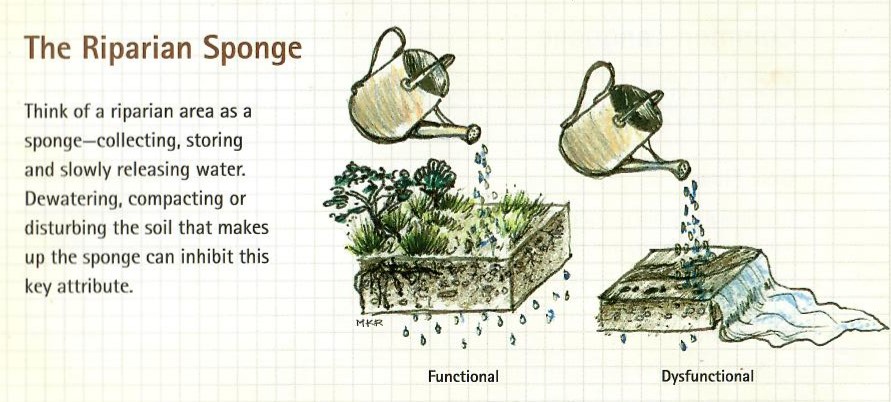
Healthy riparian areas help sustain the Hill Country’s iconic, clear creeks and rivers. At the boundary between land and water, riparian areas are natural infrastructure that help filter and slow stormwater, prevent erosion, trap sediment and uptake nutrients, and allow for infiltration and recharge into the groundwater system. Conserving healthy riparian areas while allowing recreational access is a common challenge among public and private landowners with creek and river frontage.
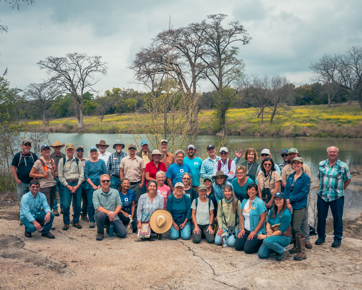
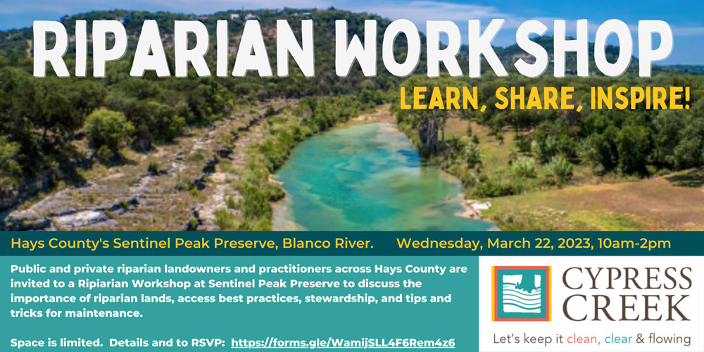
As part of the Cypress Creek Watershed Protection Plan, Riparian Workshop at Sentinel Peak Preserve was an opportunity for public and private landowners and practitioners to learn from experts, share successes and challenges, and inspire more effective stewardship.
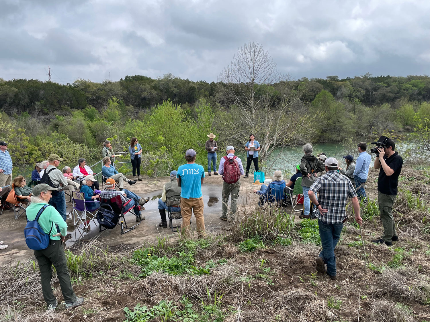
Even though it is outside the Cypress Creek watershed, Hays County has graciously hosted the workshop at Sentinel Peak Preserve on March 22 from 10-2pm. The County finalized purchase of the preserve in 2022, but there is a lot of research and prep work to do before it is ready for public access. The Riparian Workshop offered an opportunity to see the beginning of work and restoration efforts there and provide an amazing backdrop for discussion about the importance of riparian lands, access best practices, stewardship, and tips and tricks for maintenance.
————————————
Workshop Purpose and Sentinel Peak Preserve Overview
Presenters: Robin Gary (Watershed Association) with Jay Taylor and Alexandra Thompson (Hays County)
 Over 40 presenters and participants attended the workshop at Hays County’s Sentinel Peak Preserve. Prior to the workshop, participants submitted input on what information would be most useful to them and what they considered most challenging aspects to riparian land management to help inform the presentations.
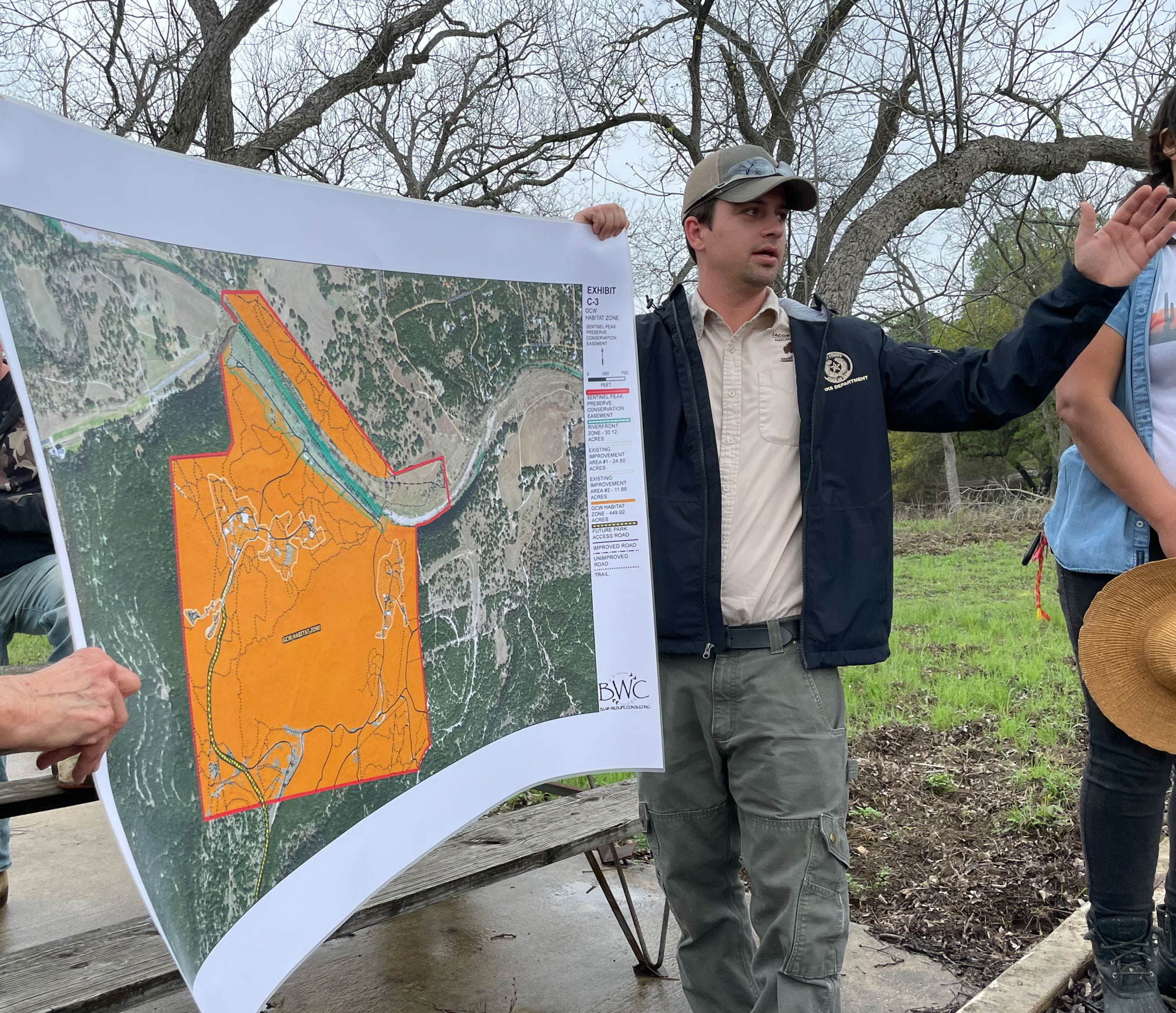
The County finalized the purchase of the Sentinel Peak Preserve property in 2022. County staff and contractors are currently focused on baseline elevation, infrastructure, habitat, and endangered species surveys. This information will inform site design and infrastructure development that complies with the existing Conservation Easement held by the Texas Nature Conservancy, land and water stewardship goals, and public access.
Riparian Habitat and Utility of Evaluations/Surveys
Presenters: Jenna Walker, Sandra Arismendez, Desiree Jackson (Meadows Center) and Jay Taylor and Katherine Sturdivant (Hays County Parks)
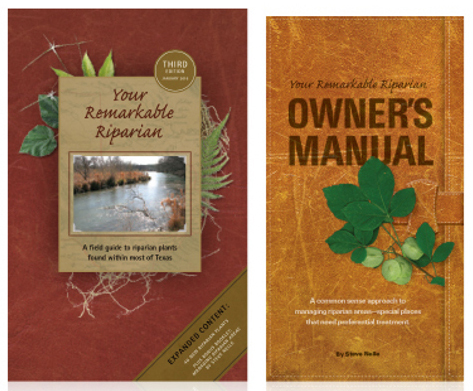 The Texas Stream Team offers a training in Riparian Habitat Evaluation as a way to document ten riparian health indicators including active floodplain, energy dissipation, new plant colonization, stabilizing vegetation, age diversity, species diversity, plant vigor, water storage, bank/channel erosion, sediment deposition. Key references for plant identification and stewardship activities are the Remarkable Riparian Field Guide to Riparian Plants, the Remarkable Riparian Owners Manual, and the Texas Parks and Wildlife Troubleshooting Invasive Plants Pocket Guide (Bookset available here).
Hays County parks staff have taken the Riparian Evaluation Training and have set up a monitoring site at the downstream end of the Preserve. The intention is to conduct evaluations twice a year to document changes in conditions and plant species through time. Data will be submitted to the Texas Stream Team. Attendees and presenters identified many invasive species such as bastard cabbage, leaks, chinaberry, johnson grass, and ample evidence of recent wild hog activity. However, highly desirable natives were also identified including switch grass and golden cheeked warblers. Restoration activities along the south bank of the riparian area within the Preserve would greatly increase habitat, species diversity, and bank stability.
Natives/Invasives, Restoration, Access Challenges
Presenters: Valerie Tamburri (Treefolks) and Cait McCann & Kevin Thuesen (City of Austin Water Quality Protection Lands)
 To mitigate flood impacts along the Blanco after the historic 2015 flood, Treefolks implemented a restoration program that is free for landowners: Central Texas Floodplain Reforestation Program. Staff and volunteers (often Texas Master Naturalists) overplant riparian areas with bald cypress, cottonwood, and box elder seedlings (to name a few). They plan to plant 4 trees for every one they expect to survive—one for drought, one for wildlife, one for flood, and one to live. Significant effort has been made to help to keep transplants alive. Staff have tried watering stations, incorporating native riparian seeds into the soil around the seedling to encourage positive plant recruitment, fencing, wire cages around individual trees, and mycorrhizal supplements to help encourage growth and protect growing trees. As part of the program, landowners sign an agreement to maintain grow zones where the restoration efforts are focused. And Treefolks offers carbon credits based on how many acres are reforested to keep the program free to landowners.
The City of Austin Water Quality Protection Lands program (Water Quality Protection Lands (WQPL) leverages the strengths and utility of native plants to help clean runoff and optimize recharge to the Edwards Aquifer. Maintaining over 34,000 acres of conservation lands and protecting that land from development removes the greatest threats to water quality to the groundwater system. Native plants are uniquely suited to the Texas heat and frequent droughts because of long roots, which also provide incredible erosion control, water filtration, and allow for water infiltration. They require no fertilizer or pesticide, because they are adapted to local soils and animal communities. The Native Plant Society of Texas offers additional information on native plants. To encourage restoration, WQPL staff are helped by volunteers that help harvest seeds, sort them, and help spread seeds. Using local seeds to encourage native plant restoration is highly beneficial, though very labor intensive. Volunteers cannot be thanked enough for donating their time, energy, and help to restoration efforts! Staff often uses prescribed fire, solarization, and very seldom hand removal to discourage and/or remove invasive plants. Invasive plants lead to a monoculture that does not support the diversity of species that a native riparian zone offers.
Kevin Thuesen, WQPL Land Manager, described a healthy riparian area as being able to keep a conquistador out. It was evident from the active feral hog activity, tree damage, and invasive plants that the south bank of the preserve was not as healthy as the north bank of the preserve, which has dense stands of trees with extensive underbrush. Hogs naturally gravitate to the less cluttered, loose soils of the degraded habitat on the south bank.
The group discussed the benefits of creating access areas while preserving much of the riparian area intact. The erosion control aspects of healthy riparian areas rose to the top of the list of benefits. Wildlife viewing, beauty of native plants, and natural feel also were popular in discussions. Common concerns included maintaining riparian areas with mowing to avoid snakes, but many pointed out that snakes will avoid open areas when more dense, shelter is available. Good examples of limited riparian access balanced with healthy riparian areas mentioned included John Knox Ranch and Blue Hole Regional Park.
Hydrogeology, Drought, Water Quality
Presenters: Robin Gary (Watershed Association) and Sandra Arismendez (Meadows Center)
In western Hays County, springs flowing from the Middle Trinity aquifer supply the baseflow to the Blanco River and Cypress Creek. The Hill Country’s karst landscape allows water to quickly enter groundwater systems and emerge as springs which contribute to creek flow, and the cycle is repeated again. The Trinity Aquifer, therefore, is a contributing water supply to the Edwards Aquifer. When Trinity Aquifer groundwater levels, spring flow, and therefore creek or river flows decline, inflows to the Edwards Aquifer also decline. Many people view groundwater levels as static or constant, however, water levels fluctuate just like water levels in the area lakes. During floods and wet weather patterns, water levels rise; and during drought and dry periods, water levels decline. The Blanco River has gaining and losing sections; the gaining sections are where springs provide baseflow, and the losing sections are where faults, fractures, caves, or swallets channel water down into the groundwater system recharging the aquifer.
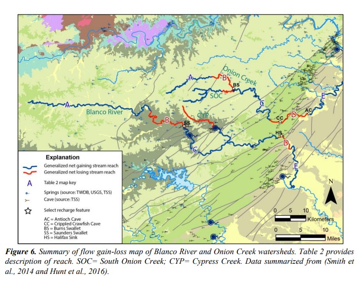
Looking at data from gauging stations along the river is one way to estimate how much water is recharging the aquifers and how much groundwater storage there is to supply spring flow and groundwater supplies. From upstream to downstream, gauge location links are: the LCRA Blanco River at Blanco, the USGS Blanco River at Valley View Rd (Trinity Aquifer recharge zone), the USGS Blanco River at Fischer Store Rd (Trinity Aquifer spring reach), the USGS Jacob’s Well (Trinity Aquifer spring reach), USGS Blanco River at Wimberley (below Cypress Creek), the USGS Blanco River at Halifax Ranch, the USGS Blanco River at Kyle (Edwards Aquifer recharge zone), and the USGS Blanco River at San Marcos (Edwards Aquifer recharge zone), and compare to the USGS San Marcos River at San Marcos (Edwards Aquifer spring reach). Also check the USGS National Water Dashboard for real time measurements (note: not all above stations are shown on the viewer): https://dashboard.waterdata.usgs.gov/app/nwd/en/?aoi=wsc-oktx
You can’t have water quality without water. Maintaining spring flow is crucial to protecting water quality in Cypress Creek and the Blanco River. A number of programs help monitor these important waterways. The Wimberley Water Advisory Group has volunteers that sample 12 sites for bacteria during the swimming season. The Texas Stream Team has volunteers that sample field parameters, bacteria, and basic nutrients monthly throughout the year (access data here). The Watershed Association, Protect Our Blanco, and Cypress Creek Project partners fund 3 monthly and 9 quarterly sampling sites for quality assured field parameter, nutrient, and flow data collected by the Meadows Center as part of the Clean Rivers Program for the Guadalupe-Blanco River Authority region (note: there is a significant time lag before data are published because of the review process).
Useful links:
Websites for presenters/organizers:
-
- Cypress Creek Project – Watershed Protection Plan
- Watershed Association – Hydro Report and Monitoring Sites links, Wimberley Water Advisory Group Bacteria Monitoring, Blanco Water Reclamation Task Force, Clean Rivers Program
- City of Austin Water Quality Protection Land – Program Overview, Volunteer and Hiking Opportunities
- Meadows Center – Texas Stream Team, Riparian Evaluation
- Treefolks – Organization Overview, Central Texas Floodplain Reforestation Program
- Hays County – Parks and Open Space Bond Status, Sentinel Peak Preserve Purchase Announcement
- Clean Rivers Program: Guadalupe-Blanco River Authority area
Useful Links